 lop News
According to recent reports, multiple seasonal climate models are pointing in the same direction — and that direction is trouble.
According to recent reports, the world may be heading toward an El Niño climate pattern that could rank among the strongest on record. What has reportedly caught scientists’ attention is the degree of consensus — seasonal models typically diverge on timing, intensity, and even whether El Niño will materialize. Some forecasts suggest that current models are aligning more closely than usual.
What El Niño Does
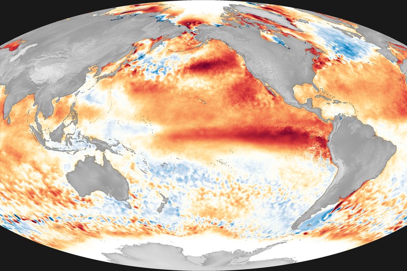
El Niño is a natural climate pattern driven by warmer-than-average sea surface temperatures in the central and eastern equatorial Pacific. It emerges every two to seven years and reshapes global weather by redirecting rainfall — soaking some regions that are normally dry and parching others that expect rain.
The 2015-2016 El Niño, one of the strongest on record, offers a preview of what a severe event looks like. It contributed to mass coral bleaching across the Great Barrier Reef, crop-withering drought in Southeast Asia and southern Africa, and destructive flooding along South America’s Pacific coast. If projections hold, some analysts suggest this next event could rival or exceed it.
Where the Damage Falls
If the predictions hold, the impacts will follow patterns that climate scientists have documented across decades of El Niño events:
Australia and Southeast Asia face the sharpest drought risk. Reduced rainfall would hit rice production in Thailand and Vietnam — the world’s second- and third-largest rice exporters — along with palm oil output in Indonesia and Malaysia, which together supply roughly 85 percent of the global market.
South America’s western coast, particularly Peru and Ecuador, braces for heavier rainfall and flooding. Northern Brazil, by contrast, tends to dry out during strong El Niño years, stressing a region already dealing with deforestation and land-use pressures.
Southern and East Africa lean drier, worsening food insecurity in regions where harvests are already inconsistent and supply chains are fragile.
The southern US typically sees wetter conditions during El Niño winters, while northern states trend warmer. The agricultural net effect depends heavily on when the pattern peaks and how long it persists.
From Weather to Economics
El Niño becomes an economic story the moment it touches major crop-producing regions.
Global food markets are sensitive to supply shocks. During the 2015-2016 event, production shortfalls in affected regions contributed to food price increases that hit importing nations — many of them low-income — disproportionately hard. A stronger El Niño could mean deeper disruptions to rice, palm oil, coffee, and cocoa supplies, all heavily concentrated in vulnerable zones.
Agricultural futures prices typically move on El Niño projections well before actual crop damage materializes, as traders and food companies hedge against potential supply disruptions.
The UN’s Food and Agriculture Organization has documented how previous strong El Niño events pushed millions into food insecurity. Early forecasting provides a window for governments and aid organizations to prepare, but the resources required scale with the severity of the event.
The Bigger Pattern
If this El Niño develops as projected, it will join a cluster of extreme events concentrated in recent decades. The three strongest El Niño events on record — 1982-83, 1997-98, and 2015-16 — all occurred within the past forty years. Researchers are still studying whether that clustering reflects the influence of climate change on the Pacific ocean-atmosphere system. The correlation is suggestive; the causation is not yet settled.
What is settled, for now, is the model consensus. Seasonal forecasting is inherently uncertain — ocean-atmosphere dynamics are complex, and predictions beyond a few months carry wide error bars. When independent models converge tightly around a single outcome, forecasters take notice.
What Happens Next
El Niño events typically build over months and peak during the Northern Hemisphere winter. If the projections hold, the most severe impacts would likely arrive between late 2026 and early 2027.
National meteorological agencies and the World Meteorological Organization are updating their outlooks as new ocean temperature data comes in. Some governments in vulnerable regions have already begun issuing preparedness guidance to farmers and emergency services.
The models are aligned. The forecast is serious. The question is whether the response will match what’s coming — and whether reality follows the models as closely as the models are following each other.
Discussion (9)