 lop News
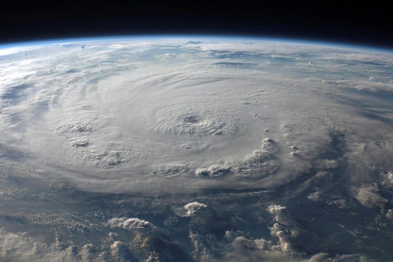
One hundred and seventy-five miles per hour. A 17-mile-wide eye. A track that passes directly over Tinian and Saipan sometime tonight, local time.
Super Typhoon Sinlaku, the strongest tropical cyclone on Earth so far in 2026, is hours from crossing the US Northern Mariana Islands as a Category 4 or 5 storm. The National Weather Service’s language leaves little room for interpretation: devastating damage is possible. Nearly all metal roof homes will be destroyed. Electricity and water will be unavailable for days and perhaps weeks.
About 50,000 people live on the three islands under typhoon warnings — Saipan, Tinian, and Rota — with most concentrated on Saipan, the capital of the Commonwealth of the Northern Mariana Islands. Guam, a separate US territory roughly 150 miles to the south with approximately 170,000 residents, is under a tropical storm warning and typhoon watch. Even without a direct hit, Guam could see sustained tropical storm-force winds of 50 to 60 mph with gusts to 70 mph, 6 to 12 inches of rain, and coastal inundation of 1 to 3 feet.
A strategic hub in the storm’s shadow
Guam is not just a Pacific island. The US military controls roughly one-third of its landmass, and it serves as a critical forward hub for American forces in the region — home to Andersen Air Base and Naval Base Guam, both of which fall under the current tropical storm warning. Military officials have instructed personnel to shelter in place.
The island is still scarred by Typhoon Mawar, which knocked out power across Guam for days in 2023. This storm could test the territory’s infrastructure all over again.
The humanitarian response, under unusual strain
President Donald Trump approved emergency disaster declarations for both Guam and the Northern Mariana Islands over the weekend, unlocking federal resources. FEMA said it has deployed nearly 100 staff to the region, along with personnel from the Environmental Protection Agency, the Department of Transportation, and the US Army Corps of Engineers.
“We are ready to respond to this event,” FEMA regional administrator Robert Fenton said from Guam on Sunday.
The response is unfolding against an awkward backdrop: the record-long Department of Homeland Security shutdown. FEMA says its emergency functions continue during the funding impasse, backed by roughly $3.6 billion remaining in its disaster relief fund as of late March. Over 10,000 disaster personnel remain on payroll.
In Guam, more than 2,200 residents have already moved into public shelters at schools across the island. Public schools and non-essential government services are closed until the territory returns to its lowest storm-readiness condition — something officials describe as unlikely before Tuesday at the earliest.
A storm for the record books
Sinlaku rapidly intensified from a Category 1 typhoon to a super typhoon over the weekend, reaching peak estimated winds of 185 mph with a central pressure of 890 millibars. According to hurricane expert Dr. Jeff Masters, cited by Weather.com, Sinlaku tied for the second-strongest January-through-April typhoon on record by wind speed, matching Super Typhoon Hester in 1953 and trailing only Super Typhoon Surigae in April 2021.
Most Northwest Pacific typhoons form between July and November. A storm of this intensity in mid-April is rare.
For Tinian and Saipan specifically, this is the strongest typhoon to approach since Category 5 Super Typhoon Yutu devastated the islands in October 2018. The forecast calls for storm surge of 5 to 8 feet — potentially reaching 10 to 15 feet in windward areas — along with 15 to 25 inches of rainfall.
The Weather Service’s local statement for Tinian and Saipan is blunt about what happens to anyone caught in the open: persons, pets, and livestock struck by wind-blown debris will be injured or killed.
Beyond the immediate destruction, Sinlaku may have downstream global consequences. Along with now-dissipated Cyclone Maila in the Southern Hemisphere, the twin cyclones generated a westerly wind burst that could help trigger El Niño conditions later this year — the same mechanism that amplified the super El Niños of 1997–98 and 2015.
Sources
- Monster typhoon in the Pacific Ocean is bearing down on group of remote US islands — Associated Press
- Super Typhoon Sinlaku, Earth’s Strongest Tropical Cyclone Of 2026, Heads Toward US Northern Marianas Strike — Weather.com
- Super Typhoon Sinlaku hits 180 mph, continues to track toward Marianas — Guam Pacific Daily News
- Hurricane Local Statement - Super Typhoon Sinlaku (04W) — National Weather Service Guam
Discussion (9)