 lop News
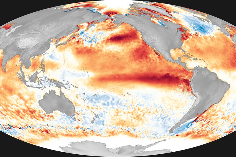
The Pacific Ocean is running a fever, and forecasters are watching the thermometer climb with a mixture of professional fascination and mounting concern. Something is building beneath the surface — something that, if the winds cooperate, could reshape weather patterns across every inhabited continent before the year is out.
Scientists are tracking what may become a “super” El Niño, a designation reserved for the most powerful iterations of the climate phenomenon that periodically warms the tropical Pacific and upends global weather. The signal has strengthened rapidly in recent weeks. Whether it crosses the threshold from merely strong to genuinely super depends on atmospheric conditions that remain, by the admission of the researchers studying them, frustratingly hard to predict.
What Makes an El Niño ‘Super’
El Niño occurs when trade winds that normally push warm surface water westward across the equatorial Pacific weaken or reverse, allowing a vast pool of unusually warm water to spread eastward toward South America. The phenomenon is measured by sea surface temperature anomalies in a region of the central and eastern Pacific designated Niño 3.4.
A standard El Niño sees anomalies of roughly 1.0 to 1.5 degrees Celsius above the long-term average. A “strong” event exceeds 1.5 degrees. The “super” label — not an official meteorological classification, but widely used among climate scientists — typically refers to events where anomalies sustain above 2.0 degrees Celsius.
Current observations show the Pacific already warming toward that strong threshold. Forecast models project continued intensification through the Northern Hemisphere’s summer and fall, according to recent climate forecasts. But models are one thing; the real atmosphere is another.
The Wind Question
The critical uncertainty is whether the atmospheric component — the Southern Oscillation — will lock into sync with the ocean warming beneath it. The phenomenon is properly called ENSO (El Niño-Southern Oscillation) because it requires both ocean and atmosphere to participate. Warm water alone doesn’t guarantee the feedback loops that amplify a developing event into something historic.
Trade wind behavior over the next several weeks will be decisive. A burst of westerly winds — blowing counter to the prevailing easterlies — can kick the ocean-atmosphere coupling into a higher gear. Without that reinforcement, the warm anomaly may plateau.
This is why forecasters express caution even as the oceanic signals look ominous. The atmosphere is volatile, and whether this event evolves into something truly historic could hinge on atmospheric shifts that remain unpredictable more than a few weeks out.
Ghost of 2015-16
The last super El Niño, in 2015-16, offers a preview of the stakes. Sea surface temperatures in the central Pacific soared well above average at peak — ranking among the strongest events in the modern record. It contributed to mass coral bleaching on the Great Barrier Reef, drought and wildfire across Southeast Asia, flooding in parts of South America, and what was then the hottest year on record globally.
Commodity markets absorbed the shock. Palm oil production in Indonesia and Malaysia fell. Wheat yields suffered across Australia. Global food prices moved upward. The insurance industry tallied billions in losses from extreme weather events linked to or worsened by the episode.
A Compounded Crisis
If a super El Niño materializes in 2026, it would arrive in a world already grappling with elevated energy prices and geopolitical disruptions to global commodity markets. The compounding effect matters.
El Niño typically suppresses the Indian monsoon — on which roughly a billion people depend for food production — and drives drought across agricultural regions of Asia, Africa, and Australia. Energy and food markets already strained by geopolitical disruption would face simultaneous climate-driven pressure. El Niño years historically correlate with price spikes in rice, wheat, and cooking oils: staples that matter most to the world’s poorest populations.
Knowns and Unknowns
The Pacific is warm. The trend is intensifying. The oceanic precursors to a major El Niño are largely in place.
But whether the atmosphere will fully commit, how strong the peak will be, and exactly which regions will bear the worst impacts — those questions remain open. El Niño’s effects are probabilistic, not deterministic. Not every vulnerable region gets hit every time.
The next two months are critical. By late July, forecasters will have a much clearer read on whether the ocean-atmosphere coupling has strengthened into something self-reinforcing — or whether the Pacific’s fever breaks before it truly spikes.
Discussion (9)