 lop News
The shaking lasted more than a minute — long enough for residents of Ternate to abandon their morning routines mid-shower and run into the streets. A magnitude 7.4 earthquake struck the Molucca Sea at 6:48 am local time on Thursday, centered roughly 120 km from the city of Ternate in Indonesia’s North Maluku province, at a depth of 35 km, according to the US Geological Survey (USGS).
One person was killed in the Manado area of North Sulawesi when a building used by the local sport authority collapsed, Deputy Chief of North Sulawesi Police Awi Setiyono told reporters. The victim was buried under the rubble, according to local official George Leo Mercy Randang, who said another person suffered a leg injury.
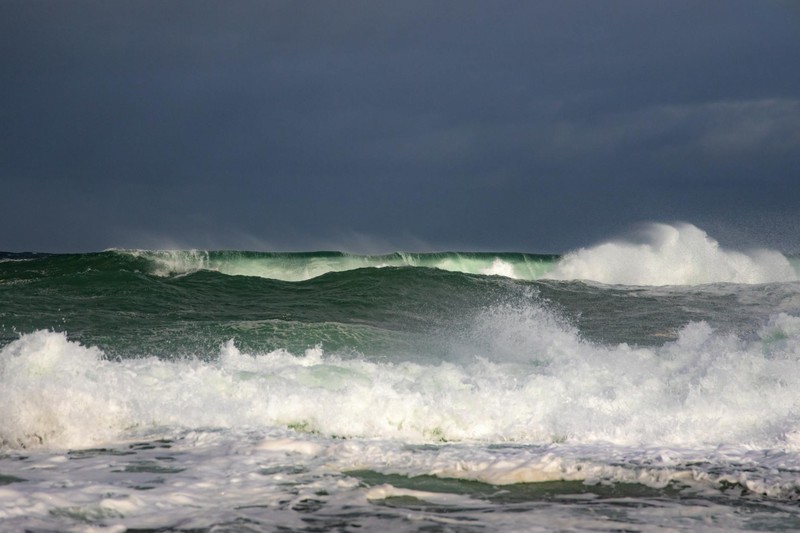
Indonesia’s meteorology agency, BMKG, reported tsunami waves at five coastal locations. The highest measured 0.75 m (2.46 ft) in North Minahasa, North Sulawesi. Waves of 0.3 m were logged in West Halmahera, and 0.2 m waves reached Bitung in northeastern Sulawesi. The Pacific Tsunami Warning Center (PTWC) issued a hazard warning for coasts within 1,000 km of the epicenter, covering parts of Indonesia, the Philippines, and Malaysia.
Just over two hours later, the PTWC lifted the alert. “Based on all available data… the tsunami threat from this earthquake has now passed,” the Hawaii-based agency said in a statement.
Minutes of Panic Across Eastern Indonesia
In Ternate, a city of more than 200,000 people in North Maluku, the tremor sent residents scrambling. “I heard it first from the walls of the house that shook,” said Budi Nurgianto, a 42-year-old resident. “When I went outside, there were many people outside. They were panicked.” He added that some had fled their homes without finishing their showers.
An AFP journalist in Manado — a city of roughly 450,000 people on Sulawesi, about 300 km west of Ternate by sea — said the quake woke him and his neighbors. “I immediately woke up and left my house. People were immediately scrambling outside. There is a school, and the pupils rushed outside.” He described the shaking as lasting “quite long” but said he did not witness significant damage in his immediate area.
A Manado resident told Reuters that people ran outside in panic. Items fell off shelves and power was cut, though her neighborhood appeared structurally intact. Indonesia’s Metro TV broadcast footage of damaged buildings in affected areas.
BMKG chief Teuku Faisal Fathani told a press conference that the agency’s modeling had indicated tsunami potential for waves of 0.5 m to 3 m (1.6 ft to 9.8 ft). Eleven aftershocks were monitored, the largest registering magnitude 5.5.
Regional Alerts Ripple Across the Pacific
The quake’s reach extended well beyond Indonesia’s borders. The US tsunami warning authorities initially flagged hazardous waves as possible along the coasts of Indonesia, the Philippines, and Malaysia. The PTWC also warned of waves of less than 0.3 m above tide levels for the coasts of Guam, Japan, Malaysia, Papua New Guinea, the Philippines, and Taiwan.
The Philippines’ seismology agency, Phivolcs, assessed the situation and concluded there was “no destructive tsunami threat” to the country. Malaysia’s meteorological department posted on Facebook that there was no immediate threat to its coastlines. Japan’s Meteorological Agency said waves of up to 0.2 m (8 inches) were possible but no damage was expected.
Regional governments in cities on Ternate and Tidore — part of the historic Spice Islands — were urged to prepare citizens for evacuation during the warning period.
Damage Assessment Ongoing
Indonesia’s national disaster agency said initial reports indicated minor to moderate damage to several houses and a church, with a fuller assessment underway. The agency urged continued vigilance. “Although relatively small, this situation still requires vigilance due to the potential for aftershocks,” it said in a statement, advising the public to remain calm and follow official guidance.
Tremors from the initial quake were felt strongly for 10 to 20 seconds in Bitung and Ternate, according to the disaster agency, with aftershocks located offshore.
The Ring of Fire’s Constant Toll
The earthquake is the latest in a long and often devastating sequence of seismic events in one of the world’s most active tectonic zones. Indonesia straddles the Pacific Ring of Fire, an arc of intense seismic activity where multiple tectonic plates collide, stretching from Japan through Southeast Asia and across the Pacific basin. The archipelago has more than 130 active volcanoes.
The disaster that haunts every Indonesian tsunami warning is the 2004 Indian Ocean earthquake. A magnitude 9.1 quake off Aceh province triggered a tsunami that killed more than 170,000 people in Indonesia alone, with the total death toll across the region exceeding 230,000. That catastrophe reshaped the Pacific’s early warning infrastructure, leading to the network of sensors and alert systems that swung into action Thursday morning.
This time, the system worked as designed. The waves were measured in centimeters rather than meters beyond the immediate coast. The warning went out within minutes. The all-clear followed within hours.
But the BMKG’s warning to the public — to stay alert, expect aftershocks, and not return to damaged structures — reflects a harder-learned lesson. In a nation built across the convergence of three major tectonic plates, no earthquake is truly over when the shaking stops.
Discussion (13)