 lop News
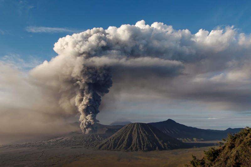
A thermal drone picked up their positions on Friday — two figures, roughly 20 to 30 metres from the rim of Mount Dukono’s main crater, where an ash column had punched 10 kilometres into the sky just hours earlier. Whether they are alive is unknown.
Indonesia’s disaster mitigation agency BNPB said on Saturday that the two Singaporean hikers, aged 27 and 30, had been located through drone surveillance, but extreme terrain and continued volcanic activity had prevented any rescue attempt. A third missing hiker, an Indonesian woman from the city of Ternate, has not been found.
Police say all three are dead, based on survivor accounts, though the rescue agency has not independently confirmed the fatalities. The bodies remain on the mountain.
Mount Dukono, on the island of Halmahera in North Maluku province, erupted at approximately 7:41am local time on Friday. The blast sent ash 10km skyward, accompanied by what Lana Saria, head of the government geology agency, described as a “booming sound” and a thick column of ash and smoke.
Hikers in a closed zone
Twenty people were on the mountain when the eruption struck — nine Singaporeans and eleven Indonesians, according to North Halmahera police chief Erlichson Pasaribu. Fifteen to 17 were evacuated safely, though figures varied between agencies as the situation unfolded. Some survivors sustained minor injuries.
None of them should have been there. Mount Dukono has sat at Level 2 on Indonesia’s four-tier volcano alert system since March 29, and authorities have maintained a 4km exclusion zone around the Malupang Warirang crater since December 2024. The official Mamuya hiking route was closed on April 17.
Erlichson said hikers had ignored social media warnings and signs at the trail entrance. “Local residents understand and don’t want to climb,” he told reporters. “Many [hikers] are foreign tourists who wish to create content.” The group’s guide and a porter were taken into custody and could face criminal charges.
Videos from a previous eruption on April 6 had circulated widely online, showing hikers scrambling near the crater as ash and debris rained down. Disaster experts warn that such footage distorts the public’s sense of the risks.
A rescue under fire
More than 100 rescuers — military, police, and search personnel — resumed operations at daybreak on Saturday, deploying two thermal drones to scan the crater area. The volcanology agency reported at least four separate eruptions on Saturday morning alone.
“The danger here is not about when it will erupt, but how large the ejected material is,” volcanologist Eko Teguh Paripurno told Channel News Asia. He described unofficial hiking routes as the biggest obstacle for authorities, saying they “effectively paralyse the monitoring system” — leaving officials with no data on who is on the mountain, or where.
One guide who was on the volcano during the eruption told BBC Indonesian he saw hikers filming drone videos roughly 50 metres from the crater moments before the blast. He heard deep tremors, turned back with his clients, and all three survived.
Mount Dukono has erupted more than 200 times since last March, according to officials. Indonesia sits on the Pacific “Ring of Fire,” with roughly 130 active volcanoes. The 1,335-metre peak on Halmahera is among the most restless — it has been erupting almost continuously for decades.
Singapore’s Ministry of Foreign Affairs said it was working with Indonesian authorities to provide consular assistance to the affected families.
Sources
- Three hikers dead after Indonesia’s Mount Dukono volcano erupts — The Guardian
- Indonesia identifies location of two Singaporean hikers at Mount Dukono but eruptions hamper rescue — Channel News Asia
- Two Singaporeans among 3 hikers feared dead after Mount Dukono eruption in Indonesia — The Straits Times
- Three dead after volcano erupts on Indonesian island — BBC News
Discussion (8)