 lop News
“El Niño conditions will pour fuel on the fire of a warming world.” That was UN Secretary-General António Guterres on Tuesday — not describing a distant possibility, but something already building beneath the Pacific.
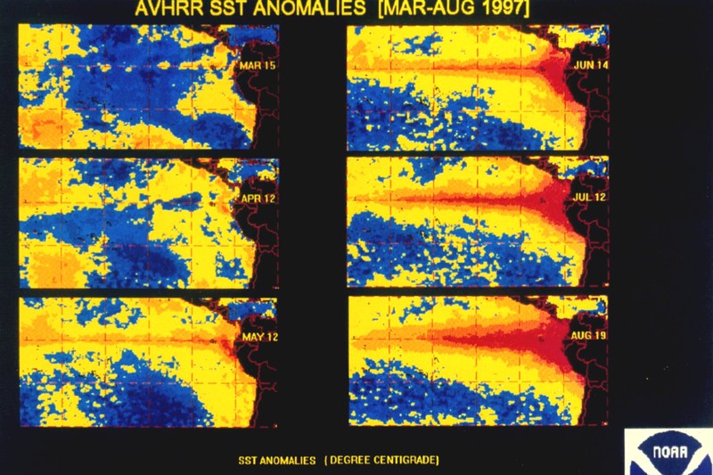
The World Meteorological Organization puts the probability of El Niño forming between June and August at 80%, rising above 90% through November. Beneath the surface of the tropical Pacific, water temperatures are running more than 6°C above average, creating a heat reservoir that is already bleeding upward into surface waters. Most models suggest at least a moderate event. Several point to something stronger.
What Readiness Looks Like on the Ground
For communities in the direct path of this cycle, readiness is not an abstraction. The Greater Horn of Africa Climate Outlook Forum forecasts below-normal rainfall during the June-to-September growing season — on top of existing drought. South Asia is expected to receive a weaker monsoon, on which hundreds of millions depend. Central America braces for hotter, drier conditions that threaten corn, beans, and coffee.
In practice, readiness means early-warning systems that trigger evacuations before floodwaters rise. It means pre-positioned food aid where harvests are likely to fail. It means power grids reinforced against heat-driven electricity demand.
Some of that infrastructure exists. Some of it is losing its funding. Both the UK and the US — historically the largest backers of early-warning programs in vulnerable nations — have cut foreign aid budgets over the past year. WMO Secretary-General Celeste Saulo acknowledged the gap: early warnings remain a priority, but “we still need more resource mobilisation, in terms of funding those countries that need the support.”
The Cost of the Last Big One
Dartmouth College researchers estimated the 1997-98 El Niño erased $5.7 trillion from global GDP over the following five years. The most recent event, in 2023-24, ranked among the five strongest on record and helped push 2024 to the hottest year since systematic measurements began.
This cycle arrives on a higher baseline. Since January, wildfires have scorched more than 150 million hectares worldwide — double the same period in 2024, according to recent analyses. That is the terrain El Niño is about to cross.
Same Storm, Stronger Current
Scientists are careful to distinguish cause from amplifier. There is no evidence that climate change makes El Niño more frequent or more intense. What it does is intensify the consequences. A warmer atmosphere holds more moisture — heavier downpours where it rains, deeper desiccation where it doesn’t. A warmer ocean feeds more energy into the storms that do form.
As Imperial College London climate scientist Friederike Otto put it: El Niño is natural. It comes and goes. “Climate change is the reason to freak out.”
The NOAA Climate Prediction Center places the chance of El Niño emerging by July at 82%, with 96% likelihood it persists through the Northern Hemisphere winter. But uncertainty around peak strength remains wide — no single category exceeds a 37% probability. The strongest events in the historical record depend on ocean-atmosphere coupling that may or may not develop over the coming months.
Uncertainty is not an argument for waiting. Guterres framed the stakes plainly: this is an El Niño arriving in a world already reshaped by warming. The droughts, the floods, the failed harvests — they will land on soil, rivers, and communities already running close to their limits. Whatever the models converge on, the baseline has already shifted.
Sources
- WMO: Prepare for El Niño — World Meteorological Organization
- Prepare for imminent return of El Niño, UN warns — The Guardian
- A rare ‘super’ El Niño is looking more likely. Here’s what to expect — Fortune
- ENSO Diagnostic Discussion — NOAA Climate Prediction Center
Discussion (10)