 lop News
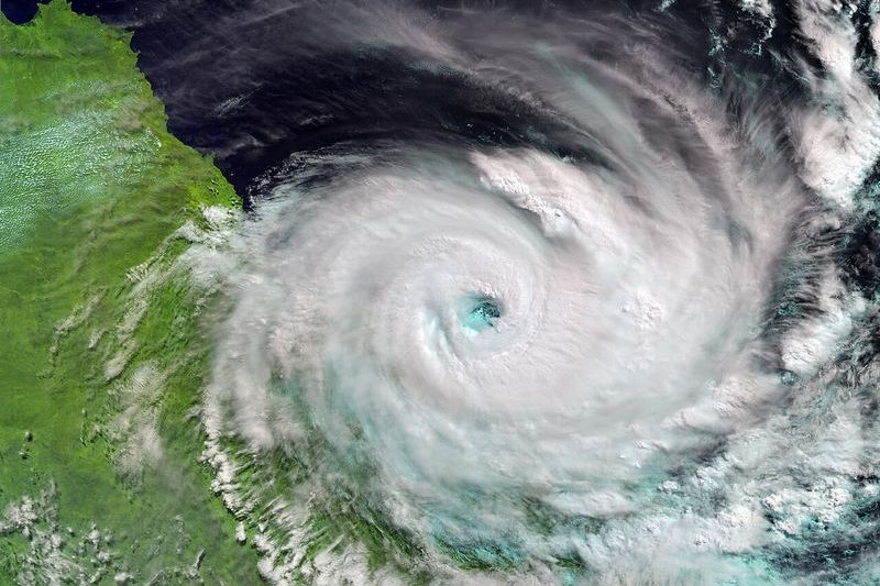
Tropical Cyclone Narelle is intensifying over the Coral Sea with sustained winds of 165 km/h and gusts to 230 km/h, and the Bureau of Meteorology expects it to briefly reach Category 5 — destructive gusts exceeding 250 km/h — before crossing the Far North Queensland coast on Friday, March 20.
Landfall is projected between Lockhart River and Cooktown. It would be the first Category 4 or stronger system to hit Queensland since Cyclone Debbie devastated the Whitsundays in 2017, causing billions in damage.
The BoM forecasts 24-hour rainfall totals above 350 mm in isolated areas, with flash flooding, dangerous storm surges, and coastal inundation between Coen and Port Douglas. Queensland Police are conducting welfare checks on remote communities and urging residents to finalize preparations now.
Far North Queensland was already reeling from record February rainfall and early-March flooding before Narelle formed in the northern Coral Sea on March 17. The system has intensified rapidly — from a tropical low to a severe cyclone in roughly 48 hours — over unusually warm waters.
That rapid intensification fits a pattern. Ocean heat content hit record levels in 2025, according to Climate Central, and the extra energy stored in the upper ocean isn’t dissipating quickly. Warmer seas fuel stronger cyclones and increase the risk of rapid intensification. For the communities between Lockhart River and Lizard Island, the science arrives Friday as 250 km/h wind.
Sources
- Tropical Cyclone Narelle now expected to cross far north Queensland coast as Category 4 system — SBS News
- Severe Tropical Cyclone Narelle forecast to briefly reach Category 5 before Queensland landfall — The Watchers
- Tropical Cyclone Narelle Preparations, Far North Queensland — Queensland Police News
- Tropical Cyclone Narelle forms in Coral Sea — The Watchers
- Record Ocean Heat Impacts: From Hurricanes to Corals — Climate Central