 lop News
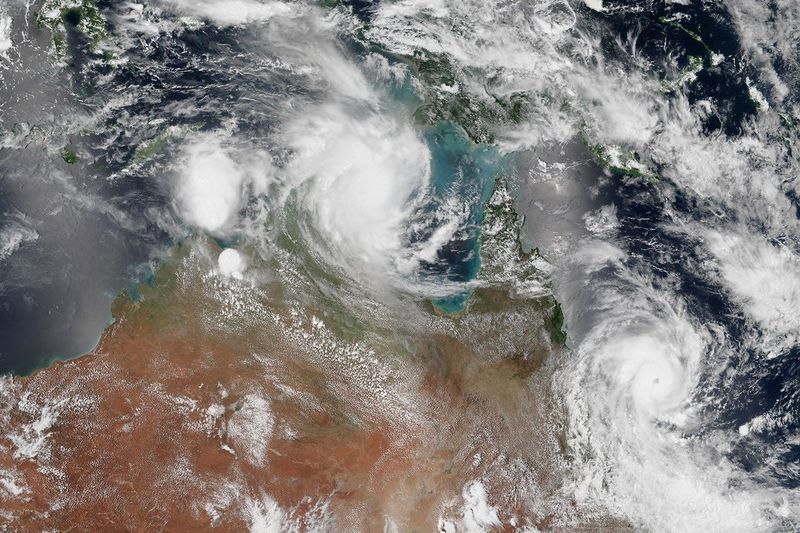
Severe Tropical Cyclone Narelle sat 515 kilometres east-northeast of Cooktown on Thursday morning, a Category 4 system drawing energy from 29–30°C waters in the Coral Sea and still intensifying. By Friday morning, the Bureau of Meteorology expects it to cross the Far North Queensland coast between Lockhart River and Cooktown — possibly at Category 5 strength, with destructive wind gusts exceeding 250 km/h.
If it reaches that threshold, Narelle will be Queensland’s first Category 5 landfall since Cyclone Marcia struck the central coast in 2015.
The Scale of the Storm
At Category 4, the BOM forecasts sustained winds above 160 km/h and gusts exceeding 225 km/h. Should Narelle tip into Category 5 before landfall — which the bureau considers plausible — average winds could surpass 200 km/h, with gusts approaching 280 km/h. Offshore, hurricane-force winds are already generating waves above 11 metres.
The fuel is the ocean itself. Sea surface temperatures of 28–30°C, coupled with low vertical wind shear and high atmospheric moisture, have created near-ideal conditions for rapid intensification. An approaching upper-level trough is expected to enhance outflow aloft, giving the storm further room to strengthen.
Rainfall totals could exceed 350 mm in isolated areas near the landfall zone, with 100 mm or more expected across broad swathes of Cape York Peninsula. The BOM has warned of flash flooding between Cape Melville and Cape Tribulation, and a “dangerous storm tide” at Princess Charlotte Bay — a region that holds an unenviable record: the 13-metre surge generated by Cyclone Mahina in 1899, the largest from any tropical cyclone ever documented.
A Closing Window
Queensland Premier David Crisafulli did not hedge. “This may be the biggest system that many people have seen in living memory,” he said Thursday. “The window to act is obviously closing.”
For some communities, it has already closed. Port Stewart — fewer than 20 residents — has been evacuated to Coen. Lizard Island’s tourists and staff have been relocated to Cooktown. Douglas Shire residents north of the Daintree River have been ordered to leave immediately, with authorities warning that roads will become impassable once rain sets in and the Daintree ferry may suspend service at short notice.
Schools across the affected region are closed Thursday and Friday. Flights to Coen and Lockhart River have been cancelled. Fifty police officers from Brisbane and Cairns are being flown to Cape York to assist with preparations and welfare checks in remote communities.
Coen — population 320 and squarely in Narelle’s forecast path — has no dedicated cyclone shelter. The community wellbeing centre has been designated the safest building in town. One community leader offered a longer view: “The elders were saying over 60 years ago, there was a big cyclone that actually did tremendous damage here in Coen.”
Not everyone is rattled. One local business owner told SBS they had stocked up on generators, fuel, and supplies. “We’ve got heaps of beer, food and fuel — we’re good to go.”
A Three-State Storm
Narelle is not expected to be a one-act event. After crossing the coast, the cyclone will track westward across Cape York Peninsula, weakening to roughly Category 2. But the Gulf of Carpentaria’s warm waters could re-energise it; the BOM forecasts Narelle may re-intensify to severe tropical cyclone strength before making a second landfall on the Northern Territory coast — a trajectory that mirrors Cyclone Ingrid’s rare three-state crossing in 2005.
The timing is brutal. Six hundred people displaced from flooded Northern Territory communities at Daly River and Palumpa already sit in emergency shelters. They may face a second severe system before the first has fully receded.
Fewer Storms, Stronger Ones
The conditions powering Narelle fit a pattern that climate researchers have been tracking for decades. CSIRO data shows the total number of tropical cyclones in the Australian region has declined over the past 30 years, but the proportion reaching severe intensity has increased. Observational studies estimate roughly 5 percent more maximum intensity per degree Celsius of ocean warming. Warmer seas also load the atmosphere with more moisture, amplifying rainfall and flooding risk.
The Coral Sea this March has been running well above 28°C — conditions that effectively reload the gun for any tropical disturbance passing through.
A BOM senior meteorologist offered one small assurance on Thursday: “We have a good degree of confidence about where it’s going to go.”
Where it’s going is directly at Far North Queensland. Landfall is expected Friday morning.
Sources
- Tropical Cyclone Narelle to make landfall in far north Qld on Friday — The Guardian
- The biggest ‘in living memory’: What we know about Tropical Cyclone Narelle — SBS News
- Severe Tropical Cyclone Narelle forecast to briefly reach Category 5 — The Watchers
- Cyclone Narelle to reach category 5 before Queensland landfall — Weatherzone
- Tropical Cyclone Narelle to deliver ‘hurricane-force’ winds — RNZ
- Tropical Cyclone Narelle Preparations, Far North Queensland — Queensland Police
- Cyclone Watch: Evacuate now if you are leaving the region — Newsport Daily
- State braces as biggest cyclone ‘in living memory’ looms — InDaily Queensland
- Tropical cyclones and climate change — CSIRO